


ページの本文です。
Hizako ichirizuka: The Hizako Distance-Marking Mound
|
Category: |
Municipally Designated Historic Site |
|
Title: |
Hizako ichirizuka The Hizako Distance-Marking Mound 膝子一里塚 |
|
No. of features: |
One feature |
|
Designated: |
January 13, 1963 |
|
Location: |
527-1 Hizako, Minuma Ward and others |
|
Owner: |
The Hizako Resident`s Association |
|
Description: |
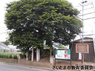
Ichirizuka are earthen mounds that served as distance markers for travelers. They were constructed along roads in patterns that extended from Edo`s Nihombashi bridge in increments of “ri” (about 4 km/ 2.44 miles). This ichirizuka mound was constructed during the early Edo period (1603-1868). It was positioned 8 ri from Edo and 1 ri from Iwatsuki on the Nikko Onari Kaido highway. At the time, it was part of a pair of mounds topped with Japanese hackberry (Celtis sinensis) trees that flanked the road. The westernmost mound was cleared during the Meiji period, and the hackberry on the remaining mound is a replacement for the original tree. |
|
Associated Texts: |
(1960). “Cultural Properties in Omiya” (vol. 1). Omiya Municipal Board of Education. (1965). “Cultural Properties in Omiya”. Omiya Municipal Board of Education. (1987). “Cultural Properties in Omiya” (vol. 3). Omiya Municipal Board of Education. |
|
Please be courteous towards other visitors, locals, and the site’s owners/curators when visiting this cultural property. |
|
|
Inquiries (Japanese only) Cultural Heritage Preservation Division, Department of Lifelong Learning, Board of Education Secretariat TEL:048-829-1723 FAX:048-829-1989 |
|
|
https://www.city.saitama.jp/004/005/006/001/005/001/003/p000497.html |
|